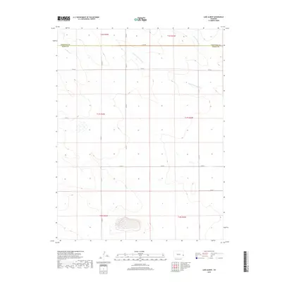
2019 Map of Lake Albert
USGS Topo · Published 2019About this map
The High Plains drainage of S Fork White Woman Cr and the main branch of White Woman Cr define this landscape along the border of Cheyenne County and Kiowa County. This modern survey illustrates the expansive grid of the Public Land Survey System, with township boundaries for t16s r43w, t17s r43w, and t18s r43w clearly delineated alongside their counterparts in Range 42 West. The terrain is structured by a network of county roads including Co RD BB, Co RD Aa, and north-south routes like Co RD 71 and Co RD 72. This map provides a clear view of the rural infrastructure and ephemeral water features in this portion of eastern Colorado, where the vast open spaces are organized by the section lines and local thoroughfares that sustain the region's agricultural character.
Find a feature on this map
18 named features on this map. Tap any name to fly to it.
Don’t see what you’re looking for? This feature index may not catch every label — zoom into the map to look around manually.
Map Details
Editions of this 2019 Lake Albert Map
This is the sole edition of this map. No revisions or reprints were ever made.
Other maps of this area

1890 · Granada
USGS Topo · 1:125,000

1892 · Cheyenne Wells
USGS Topo · 1:125,000

1892 · Granada
USGS Topo · 1:125,000

1894 · Cheyenne Wells
USGS Topo · 1:125,000

1894 · Granada
USGS Topo · 1:125,000

1954 · Lamar
USGS Topo · 1:250,000

1958 · Lamar
USGS Topo · 1:250,000

1968 · Stuart
USGS Topo · 1:24,000

1968 · Sheridan Lake
USGS Topo · 1:24,000
1968 · Towner
USGS Topo · 1:24,000