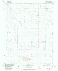
1982 Map of Lake Albert
USGS Topo · Published 1982About this map
Lake Albert and its surrounding high plains landscape dominate this 1982 survey along the border of Cheyenne and Kiowa counties. The terrain is defined by the ephemeral drainage patterns of the South Fork and White Woman Creek, which carve subtle pathways across the arid eastern Colorado plateau. This era of land use is marked by scattered infrastructure designed to support ranching and resource extraction, notably several Tanks and Wells distributed across the sections. A Gravel Pit located in the northeastern corner near the Kiowa county line indicates the localized industrial activity of the period, while the prominent basin of Lake Albert provides a central hydrologic landmark for the region.
Find a feature on this map
7 named features on this map. Tap any name to fly to it.
Don’t see what you’re looking for? This feature index may not catch every label — zoom into the map to look around manually.
Map Details
Editions of this 1982 Lake Albert Map
This is the sole edition of this map. No revisions or reprints were ever made.
Other maps of this area

1890 · Granada
USGS Topo · 1:125,000

1892 · Cheyenne Wells
USGS Topo · 1:125,000

1892 · Granada
USGS Topo · 1:125,000

1894 · Cheyenne Wells
USGS Topo · 1:125,000

1894 · Granada
USGS Topo · 1:125,000

1954 · Lamar
USGS Topo · 1:250,000

1958 · Lamar
USGS Topo · 1:250,000

1968 · Stuart
USGS Topo · 1:24,000

1968 · Sheridan Lake
USGS Topo · 1:24,000
1968 · Towner
USGS Topo · 1:24,000