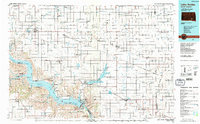
1986 Map of Lake Andes
USGS Topo · Published 1988About this map
Lake Francis Case and the Missouri River dominate this mid-1980s landscape of South Dakota, reflecting the significant water management and recreation infrastructure of the era. The map details the Yankton Indian Reservation and the Fort Randall Military Reservation Boundary, providing a clear look at the intersection of federal, tribal, and private lands. The regional economy is anchored by agricultural settlements and rail lines, including the Chicago Milwaukee St Paul and Pacific railroad, while an Old Railroad Grade suggests a changing transport network.
Find a feature on this map
129 named features on this map. Tap any name to fly to it.
Don’t see what you’re looking for? This feature index may not catch every label — zoom into the map to look around manually.
Map Details
Editions of this 1986 Lake Andes Map
3 editions found
Other maps of this area

1898 · Olivet
USGS Topo · 1:125,000

1899 · Mitchell
USGS Topo · 1:125,000

1899 · Alexandria
USGS Topo · 1:125,000

1951 · Butte NW
USGS Topo · 1:24,000

1951 · Naper
USGS Topo · 1:24,000

1955 · Sioux City
USGS Topo · 1:250,000

1955 · Sioux Falls
USGS Topo · 1:250,000

1955 · Mitchell
USGS Topo · 1:250,000

1955 · O'Neill
USGS Topo · 1:250,000

1957 · Ethan
USGS Topo · 1:24,000