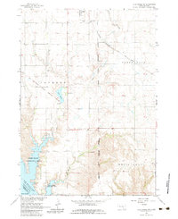
1964 Map of Lake Andes NW
USGS Topo · Published 1983About this map
Geddes stands at the northern edge of this Missouri River Basin survey, serving as a focal point for a landscape defined by its reservation history and water management. The survey documents the complex geography of the Yankton Indian Reservation Boundary and the Jackson Reservation Boundary, which intersect with older transit corridors like the Old Fort Randall Road and the Old Military Road. In the south, the expansion of the Missouri River into Lake Francis Case has reshaped the terrain, creating the Pease Creek Recreation Area and Spring Creek Recreation Area. Notable local landmarks include St Anns Cem, Pleasant Lawn Cem, and the small inland Lake Geddes, while the Chicago Military and St Paul and Pacific rail line cuts across the northeastern corner past Goose Lake.
Find a feature on this map
29 named features on this map. Tap any name to fly to it.
Don’t see what you’re looking for? This feature index may not catch every label — zoom into the map to look around manually.
Map Details
Editions of this 1964 Lake Andes NW Map
2 editions found
Other maps of this area

1955 · Mitchell
USGS Topo · 1:250,000

1959 · Mitchell
USGS Topo · 1:250,000

1964 · Campbell Creek
USGS Topo · 1:24,000

1964 · Lake Andes NW
USGS Topo · 1:24,000

1964 · Fort Randall Dam
USGS Topo · 1:24,000

1964 · Lake Andes SW
USGS Topo · 1:24,000
1964 · South Scalp Creek
USGS Topo · 1:24,000

1964 · Lake Andes
USGS Topo · 1:24,000

1977 · Lake Andes NW
USGS Topo · 1:24,000
1977 · Lake Andes
USGS Topo · 1:24,000
Featured Places
- Geddes, SD
- Jackson Township, SD
- Goose Lake Township, SD
- Pease Creek Hutterite Colony, SD
- White Swan Township, SD