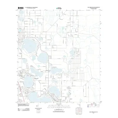
2012 Map of Lake Arbuckle SW
USGS Topo · Published 2012About this map
Lake Jackson and Lake Sebring anchor the southern landscape of this central Florida region, where a dense network of water bodies defines the local geography. Residential developments like Sebring Shores and Lakemont are situated among these lakes, connected by a grid of thoroughfares including Co Hwy 17A and Co Hwy 64. The area is notable for its numerous named basins, from the larger Dinner Lake to more uniquely named features such as Counterfeit Lake and Little Red Water Lake. Researchers will find several significant community landmarks, including Lakeview Memorial Gardens, Pinecrest Cem, and Lakeside Cem, which reflect the long-standing settlement patterns near the water's edge. To the east, the terrain transitions toward Carter Cr and Mud Lake, showing the hydrology that shapes this portion of Highlands County.
Find a feature on this map
204 named features on this map. Tap any name to fly to it.
Don’t see what you’re looking for? This feature index may not catch every label — zoom into the map to look around manually.
Map Details
Editions of this 2012 Lake Arbuckle SW Map
This is the sole edition of this map. No revisions or reprints were ever made.
Other maps of this area

1952 · Lake Arbuckle SW
USGS Topo · 1:24,000

1952 · Lake Arbuckle NE
USGS Topo · 1:24,000

1952 · Lake Arbuckle SE
USGS Topo · 1:24,000

1952 · Lake Arbuckle
USGS Topo · 1:24,000

1952 · Lorida
USGS Topo · 1:24,000

1952 · Sebring
USGS Topo · 1:24,000

1953 · Frostproof
USGS Topo · 1:24,000

1953 · Avon Park
USGS Topo · 1:24,000

1953 · Crewsville
USGS Topo · 1:24,000

1956 · Fort Pierce
USGS Topo · 1:250,000