
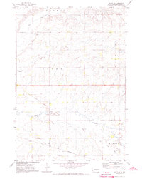
1967 Map of Lake Benton SW
USGS Topo · Published 1969About this map
Medary Creek winds through this rural prairie landscape along the border of Minnesota and South Dakota in the late 1960s. The terrain is defined by the townships of Richland, Drammen, Altona, and Elkton, showcasing a late-twentieth-century agricultural layout of section lines and scattered farmsteads. Local history is anchored at the Stolz Cem and a small Roadside Park along the highway, while several Gravel Pits indicate the local extractive industry of the time. The map provides a meticulous record of the Brookings and Lincoln County line, documenting the exact placement of fences and field lines captured during 1965 aerial photography and verified on the ground just before the decade's end.
Find a feature on this map
12 named features on this map. Tap any name to fly to it.
Don’t see what you’re looking for? This feature index may not catch every label — zoom into the map to look around manually.
Map Details
Editions of this 1967 Lake Benton SW Map
This is the sole edition of this map. No revisions or reprints were ever made.
Other maps of this area

1953 · Watertown
USGS Topo · 1:250,000

1958 · Watertown
USGS Topo · 1:250,000

1967 · Verdi
USGS Topo · 1:24,000

1967 · Lake Benton NW
USGS Topo · 1:24,000

1967 · Lake Benton
USGS Topo · 1:24,000

1967 · Lake Benton NE
USGS Topo · 1:24,000

1967 · Elkton
USGS Topo · 1:24,000

1970 · White NE
USGS Topo · 1:24,000

1972 · Flandreau NE
USGS Topo · 1:24,000
1972 · White SE
USGS Topo · 1:24,000