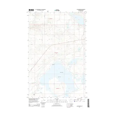
2014 Map of Lake Bowdoin
USGS Topo · Published 2014About this map
Lake Bowdoin and the surrounding wetlands of Phillips County define this high-plains landscape, where complex water management systems intersect with natural alkali flats. The 2014 topography highlights an intricate network of conservation and irrigation infrastructure, including the Dodson South Canal and Dry Lake Canal, which redirect water through a series of managed basins like the Teal Pond Complex. This environment is characterized by distinct landforms rising from the water, such as Woody Island, Long Island, and the Pelican Islands. To the north, the Milk River meanders toward the Nelson Reservoir, while smaller water bodies like Erphit Lake and several named springs, including Townsend Spring and Bebee Spring, indicate the hydrology of the northern Missouri River drainage. Protected areas such as the Lakeside Unit and Drumbo Unit emphasize the region's importance for migratory waterfowl and local habitat preservation.
Find a feature on this map
29 named features on this map. Tap any name to fly to it.
Don’t see what you’re looking for? This feature index may not catch every label — zoom into the map to look around manually.
Map Details
Editions of this 2014 Lake Bowdoin Map
This is the sole edition of this map. No revisions or reprints were ever made.
Other maps of this area

1905 · Bowdoin
USGS Topo · 1:62,500

1920 · Cowan
USGS Topo · 1:125,000

1954 · Glasgow
USGS Topo · 1:250,000

1957 · Glasgow
USGS Topo · 1:250,000

1958 · Glasgow
USGS Topo · 1:250,000
1968 · Hewitt Lake
USGS Topo · 1:24,000
1968 · Malta NE
USGS Topo · 1:24,000

1968 · Hewitt Lake SW
USGS Topo · 1:24,000

1968 · Malta East
USGS Topo · 1:24,000

1984 · Clanton Coulee
USGS Topo · 1:24,000