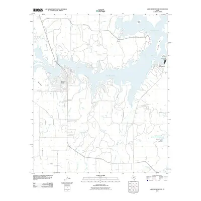
2010 Map of Lake Brownwood
USGS Topo · Published 2010About this map
Lake Brownwood dominates this central Texas landscape, its intricate shoreline creating numerous inlets like Cason Cove and providing a backdrop for residential developments such as Shamrock Shores and Lake Shore. Engineered water management is a central theme of the area, anchored by the Brownwood Dam on the Pecan Bayou and the Soil Conservation Service Site 8 Dam to the southeast. These structures transformed the drainage of Rocky Creek, Rough Creek, and the Jim Ned Branch into a major regional reservoir.
Find a feature on this map
57 named features on this map. Tap any name to fly to it.
Don’t see what you’re looking for? This feature index may not catch every label — zoom into the map to look around manually.
Map Details
Editions of this 2010 Lake Brownwood Map
This is the sole edition of this map. No revisions or reprints were ever made.
Other maps of this area

1887 · Coleman
USGS Topo · 1:125,000

1889 · Brownwood
USGS Topo · 1:125,000

1889 · Coleman
USGS Topo · 1:125,000

1894 · Brownwood
USGS Topo · 1:125,000

1924 · Coleman 1-a
USGS Topo · 1:48,000

1924 · Brownwood Reservoir Site
USGS Topo · 1:48,000

1925 · Brownwood 3-b
USGS Topo · 1:48,000

1927 · Grosvenor
USGS Topo · 1:62,500

1928 · Zephyr
USGS Topo · 1:62,500

1950 · Zephyr
USGS Topo · 1:62,500