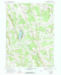
1967 Map of Lake Canadohta
USGS Topo · Published 1991About this map
Lake Canadohta serves as the focal point for this landscape in the late 1960s, surrounded by a cluster of summer homes and local landmarks like the Canadohta Ski Slope and the Lady of Fatima Chapel. The map reveals a rural economy shaped by natural resources and small crossroads settlements such as Riceville, Lincolnville, and Tillotson. Several cemeteries, including the Bloomfield Burying Ground and Shreve Ridge Cem, provide critical data points for genealogists tracing early families in Bloomfield and Athens townships.
Find a feature on this map
55 named features on this map. Tap any name to fly to it.
Don’t see what you’re looking for? This feature index may not catch every label — zoom into the map to look around manually.
Map Details
Editions of this 1967 Lake Canadohta Map
3 editions found
Other maps of this area

1927 · Townville
USGS Topo · 1:48,000

1927 · Titusville
USGS Topo · 1:62,500

1929 · Corry
USGS Topo · 1:48,000

1929 · Union City
USGS Topo · 1:62,500

1932 · Corry
USGS Topo · 1:62,500

1932 · Townville
USGS Topo · 1:62,500

1932 · Union City
USGS Topo · 1:62,500

1933 · Titusville
USGS Topo · 1:62,500

1945 · Townville
USGS Topo · 1:62,500

1957 · Warren
USGS Topo · 1:250,000