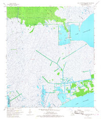
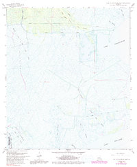
1967 Map of Lake Cataouatche West
USGS Topo · Published 1968About this map
The coastal wetlands of St. Charles Parish appear here as a complex network of waterways and industrial infrastructure in the late 1960s. Dominating the eastern portion is the wide expanse of Lake Cataouatche, which connects southward toward Lake Salvador. This environment is defined by the heavy footprint of the petroleum and timber industries, visible through the extensive Boutte Oil and Gas Field and the Louisiana Cypress Lumber tracts. Numerous canals and pipelines cut through the marsh, providing access for resource extraction.
Find a feature on this map
15 named features on this map. Tap any name to fly to it.
Don’t see what you’re looking for? This feature index may not catch every label — zoom into the map to look around manually.
Map Details
Editions of this 1967 Lake Cataouatche West Map
5 editions found
Other maps of this area

1891 · Hahnville
USGS Topo · 1:62,500

1891 · New Orleans
USGS Topo · 1:62,500

1892 · Barataria
USGS Topo · 1:62,500

1892 · Cut-Off
USGS Topo · 1:62,500

1932 · New Orleans NW
USGS Topo · 1:31,680

1932 · New Orleans SW
USGS Topo · 1:31,680

1932 · Hahnville NW
USGS Topo · 1:31,680

1932 · Hahnville SW
USGS Topo · 1:31,680

1932 · Hahnville NE
USGS Topo · 1:31,680

1935 · Luling
USGS Topo · 1:31,680