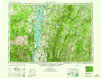
1958 Map of Lake Champlain
USGS Topo · Published 1958About this map
The Lake Champlain valley and its surrounding highlands are captured here during a period of transition in the mid-twentieth century. This sheet illustrates the complex transportation networks of the North Country, where the Delaware & Hudson RR skirts the western shore and the Central Vermont Ry connects major hubs like Burlington and St Albans. In the east, the Green Mountains dominate the terrain, featuring landmarks like Mt Mansfield and Camel's Hump, while the industrial character of the region is evident in the mining centers of Mineville and Witherbee.
Find a feature on this map
304 named features on this map. Tap any name to fly to it.
Don’t see what you’re looking for? This feature index may not catch every label — zoom into the map to look around manually.
Map Details
Editions of this 1958 Lake Champlain Map
2 editions found

Other maps of this area

1894 · Elizabethtown
USGS Topo · 1:62,500

1894 · Port Henry
USGS Topo · 1:62,500

1894 · Plattsburg
USGS Topo · 1:62,500

1894 · Ticonderoga
USGS Topo · 1:62,500

1895 · Mooers
USGS Topo · 1:62,500

1895 · Rouse Point
USGS Topo · 1:62,500

1895 · Willsboro
USGS Topo · 1:62,500

1895 · Elizabethtown
USGS Topo · 1:62,500

1895 · Mt. Marcy
USGS Topo · 1:62,500

1895 · Ausable
USGS Topo · 1:62,500