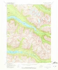
1954 Map of Lake Clark A-3
USGS Topo · Published 1972About this map
Kontrashibuna Lake and Upper Tazimina Lake dominate this glacial landscape in the southwestern Alaska interior, as documented through aerial photography and field annotations from the mid-1950s. The topography is defined by significant elevations like Copper Mountain and Tanalian Mountain, separated by high-altitude drainages such as Gladiator Basin. The drainage pattern is complex, with Kasna Creek feeding into the central lake and the Tazimina River flowing from the southern water bodies. At the time of this survey, the region remained largely undeveloped with no roads or trails recorded, emphasizing a period of wild terrain before more modern access. Notable landmarks for navigators and surveyors of this era include the Base Line and named watercourses like Currant Creek and Brooks Creek.
Find a feature on this map
13 named features on this map. Tap any name to fly to it.
Don’t see what you’re looking for? This feature index may not catch every label — zoom into the map to look around manually.
Map Details
Editions of this 1954 Lake Clark A-3 Map
2 editions found
Other maps of this area

1946 · Lake Clark
USGS Topo · 1:250,000

1951 · Lake Clark
USGS Topo · 1:250,000

1952 · Iliamna
USGS Topo · 1:250,000

1954 · Lake Clark A-3
USGS Topo · 1:63,360

1954 · Iliamna D-3
USGS Topo · 1:63,360

1954 · Lake Clark B-3
USGS Topo · 1:63,360

1954 · Iliamna D-4
USGS Topo · 1:63,360

1954 · Lake Clark A-4
USGS Topo · 1:63,360

1954 · Lake Clark B-4
USGS Topo · 1:63,360

1957 · Iliamna
USGS Topo · 1:250,000