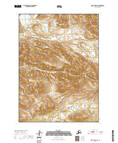
2018 Map of Lake Clark C-4 SE
USGS Topo · Published 2018About this map
Lake Clark National Preserve occupies the heart of this landscape, encompassing a high-elevation interior where the waters of the Little Mulchatna River begin their winding course. The topography is defined by significant vertical relief, with peaks rising between the drainages of College Cr and the northern reaches of the quadrangle. This area is characterized by its hydrological network rather than human infrastructure, showing the undisturbed drainage patterns of the southwestern Alaskan interior. Snipe Lake sits in the northwestern corner, serving as a prominent landmark in a region otherwise marked by steep contour lines and glacial-carved valleys. The map provides a clear look at the public land survey system divisions, including t6n r29w and t6n r28w, which organize this largely roadless terrain.
Find a feature on this map
8 named features on this map. Tap any name to fly to it.
Don’t see what you’re looking for? This feature index may not catch every label — zoom into the map to look around manually.
Map Details
Editions of this 2018 Lake Clark C-4 SE Map
This is the sole edition of this map. No revisions or reprints were ever made.
Other maps of this area

1946 · Lake Clark
USGS Topo · 1:250,000

1951 · Lake Clark
USGS Topo · 1:250,000

1954 · Lake Clark C-3
USGS Topo · 1:63,360

1954 · Lake Clark C-4
USGS Topo · 1:63,360

1954 · Lake Clark B-3
USGS Topo · 1:63,360

1954 · Lake Clark B-4
USGS Topo · 1:63,360

1958 · Lake Clark
USGS Topo · 1:250,000
2018 · Lake Clark C-4 NE
USGS Topo · 1:25,000
2018 · Lake Clark C-4 NW
USGS Topo · 1:25,000
2018 · Lake Clark C-4 SW
USGS Topo · 1:25,000