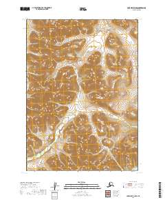
2019 Map of Lake Clark C-8 SW
USGS Topo · Published 2019About this map
Mosquito River and its primary tributary, the E Fork Mosquito River, dominate this high-altitude landscape in the Lake and Peninsula Borough. The drainage patterns here reveal a complex network of glacial or alpine runoff, where small waterways like Chunuk Cr and Sixtyfour Cr carve through steep elevation contours. The map captures a wilderness area defined by its hydrology rather than human settlement, with the only formal designations being township and range lines such as t6n r38w and t5n r37w. For those studying the geography of southwestern Alaska, this 2019 survey provides a precise look at the headwaters of the Springway Cr system before it joins larger regional basins.
Find a feature on this map
10 named features on this map. Tap any name to fly to it.
Don’t see what you’re looking for? This feature index may not catch every label — zoom into the map to look around manually.
Map Details
Editions of this 2019 Lake Clark C-8 SW Map
This is the sole edition of this map. No revisions or reprints were ever made.
Other maps of this area

1946 · Lake Clark
USGS Topo · 1:250,000

1950 · Taylor Mountains
USGS Topo · 1:250,000

1951 · Lake Clark
USGS Topo · 1:250,000

1951 · Taylor Mountains
USGS Topo · 1:250,000

1954 · Lake Clark C-8
USGS Topo · 1:63,360

1954 · Taylor Mountains
USGS Topo · 1:250,000

1954 · Taylor Mountains C-1
USGS Topo · 1:63,360

1954 · Taylor Mountains B-1
USGS Topo · 1:63,360
1954 · Lake Clark B-8
USGS Topo · 1:63,360

1958 · Lake Clark
USGS Topo · 1:250,000