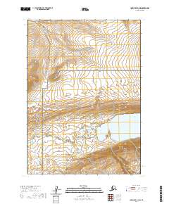
2020 Map of Lake Clark D-3 SW
USGS Topo · Published 2020About this map
Lake Clark National Park and the adjacent Lake Clark National Preserve meet in this 2020 survey of the Lake and Peninsula Borough. The landscape is defined by its transition from high mountain slopes to complex water systems. Turquoise Lake occupies the eastern boundary, while the Mulchatna Wild and Scenic River designation protects the upper reaches of the Mulchatna River as it winds through the southwestern quadrant. This protected wilderness area is marked by significant topographical relief, where seasonal drainages like Summit Cr flow through high-altitude basins. The map illustrates a strictly preserved environment, devoid of modern settlements or road networks, focusing instead on the hydrography and federally protected boundaries of this part of Alaska.
Find a feature on this map
10 named features on this map. Tap any name to fly to it.
Don’t see what you’re looking for? This feature index may not catch every label — zoom into the map to look around manually.
Map Details
Editions of this 2020 Lake Clark D-3 SW Map
This is the sole edition of this map. No revisions or reprints were ever made.
Other maps of this area

1946 · Lake Clark
USGS Topo · 1:250,000

1951 · Lake Clark
USGS Topo · 1:250,000

1954 · Lake Clark C-3
USGS Topo · 1:63,360

1954 · Lake Clark C-4
USGS Topo · 1:63,360

1954 · Lake Clark D-3
USGS Topo · 1:63,360

1954 · Lake Clark D-4
USGS Topo · 1:63,360

1958 · Lake Clark
USGS Topo · 1:250,000
2018 · Lake Clark D-3 SE
USGS Topo · 1:25,000
2018 · Lake Clark C-4 NE
USGS Topo · 1:25,000
2018 · Lake Clark C-3 NE
USGS Topo · 1:25,000