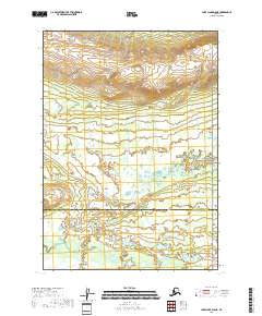
2018 Map of Lake Clark D-5 NE
USGS Topo · Published 2018About this map
The Mulchatna River meanders through the southern portion of this remote Alaskan landscape, marking a significant hydrologic feature in a region defined by extensive wetlands and complex drainage patterns. This 2018 survey documents a wilderness area where the Bethel Census Area meets the Lake and Peninsula Borough. The eastern edge of the map is protected within the Lake Clark National Preserve, highlighting the transition from open borough lands to federal conservation territory. The terrain is characterized by intricate water systems and shifting elevations that reveal the natural state of the Alaskan interior before modern development. Researchers can observe the exact boundary lines of the Public Land Survey System, including t10n r30w and t9n r30w, which provide a structural grid over this otherwise untamed river corridor.
Find a feature on this map
10 named features on this map. Tap any name to fly to it.
Don’t see what you’re looking for? This feature index may not catch every label — zoom into the map to look around manually.
Map Details
Editions of this 2018 Lake Clark D-5 NE Map
This is the sole edition of this map. No revisions or reprints were ever made.
Other maps of this area

1946 · Lake Clark
USGS Topo · 1:250,000

1951 · Lake Clark
USGS Topo · 1:250,000

1951 · Lime Hills
USGS Topo · 1:250,000

1954 · Lime Hills A-5
USGS Topo · 1:63,360

1954 · Lime Hills A-4
USGS Topo · 1:63,360

1954 · Lake Clark D-5
USGS Topo · 1:63,360

1954 · Lake Clark D-4
USGS Topo · 1:63,360

1958 · Lake Clark
USGS Topo · 1:250,000

1958 · Lime Hills
USGS Topo · 1:250,000
2018 · Lake Clark D-4 NW
USGS Topo · 1:25,000