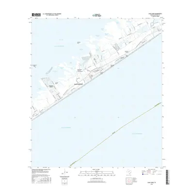
2016 Map of Lake Como
USGS Topo · Published 2016About this map
Galveston Island serves as a narrow barrier between the Gulf of Mexico and the labyrinthine marshlands of West Bay. This 2016 survey highlights the dense residential development along the shoreline, where planned communities like Jamaica Beach and Pirates Beach are linked by FM 3005 and Stewart Rd. The landward side of the island is defined by a complex network of tidal inlets and coves, such as Eckert Bayou and Starvation Cove, which reveal the fragile interface between the coastal plain and the sea. Notable landmarks include the Mary Moody Northern Amphitheater near Lake Como, a site reflecting the island's cultural geography. Further inland, The Ridge provides a slight topographic contrast to the surrounding low-lying bayous and salt marshes like Oak Bayou and Dana Cove.
Find a feature on this map
73 named features on this map. Tap any name to fly to it.
Don’t see what you’re looking for? This feature index may not catch every label — zoom into the map to look around manually.
Map Details
Editions of this 2016 Lake Como Map
This is the sole edition of this map. No revisions or reprints were ever made.
Other maps of this area

1929 · Karankawa Lake
USGS Topo · 1:24,000

1929 · Hitchcock
USGS Topo · 1:24,000

1929 · Virginia Point
USGS Topo · 1:24,000

1930 · Galveston
USGS Topo · 1:24,000

1931 · Lake Como
USGS Topo · 1:24,000

1932 · Hitchcock
USGS Topo · 1:31,680

1932 · Virginia Point
USGS Topo · 1:31,680

1933 · Karankawa Lake
USGS Topo · 1:31,680

1933 · San Luis Pass
USGS Topo · 1:31,680
1933 · Galveston
USGS Topo · 1:31,680