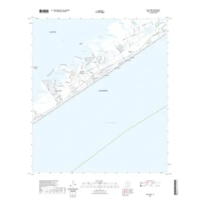
2022 Map of Lake Como
USGS Topo · Published 2022About this map
Galveston Island serves as a barrier between the Gulf of Mexico and the intricate bayous and coves of the West Bay. This modern coastal survey documents the dense residential development along the shoreline, including the established communities of Jamaica Beach, Pirates Beach, and Bermuda Beach. The landscape is defined by the tension between the open gulf and a complex network of protected waters such as Starvation Cove, Mentzel Bayou, and Eckert Bayou. Cultural landmarks like the Mary Moody Northern Amphitheater are situated near The Ridge, while the small Wern Cem provides a point of genealogical interest. The map also traces the modern road network, from Termini-San Luis Pass Rd to local lanes like Spanish Main Blvd and Carthagena Way.
Find a feature on this map
83 named features on this map. Tap any name to fly to it.
Don’t see what you’re looking for? This feature index may not catch every label — zoom into the map to look around manually.
Map Details
Editions of this 2022 Lake Como Map
This is the sole edition of this map. No revisions or reprints were ever made.
Other maps of this area

1929 · Karankawa Lake
USGS Topo · 1:24,000

1929 · Hitchcock
USGS Topo · 1:24,000

1929 · Virginia Point
USGS Topo · 1:24,000

1930 · Galveston
USGS Topo · 1:24,000

1931 · Lake Como
USGS Topo · 1:24,000

1932 · Hitchcock
USGS Topo · 1:31,680

1932 · Virginia Point
USGS Topo · 1:31,680

1933 · Karankawa Lake
USGS Topo · 1:31,680

1933 · San Luis Pass
USGS Topo · 1:31,680
1933 · Galveston
USGS Topo · 1:31,680