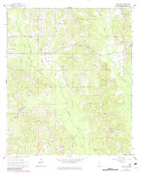
1964 Map of Lake Como
USGS Topo · Published 1982About this map
Tallahoma Creek and its various tributaries, including Piney Branch and Nuakfuppa Creek, carve a rolling landscape of timber and small-scale agriculture in rural Jasper County. The settlement of Lake Como serves as a central hub, surrounded by a dense network of country churches and burial grounds that define the local genealogy of the era. Landmarks such as Bethlehem Ch, Beat Line Ch, and St John Ch are scattered across the terrain, often accompanied by family and community cemeteries like Enon Cem and Mt Pleasant Cem. The presence of several Claypit sites and the Holder Lookout Tower suggest a landscape balancing natural resource extraction with forest management. A prominent Pipeline cuts across the quadrangle, signaling the modern industrial infrastructure overlaying these established rural communities during the mid-twentieth century.
Find a feature on this map
26 named features on this map. Tap any name to fly to it.
Don’t see what you’re looking for? This feature index may not catch every label — zoom into the map to look around manually.
Map Details
Editions of this 1964 Lake Como Map
2 editions found
Other maps of this area

1953 · Hattiesburg
USGS Topo · 1:250,000

1953 · Meridian
USGS Topo · 1:250,000

1957 · Meridian
USGS Topo · 1:250,000

1958 · Hattiesburg
USGS Topo · 1:250,000

1963 · Waldrup
USGS Topo · 1:24,000

1964 · Moss
USGS Topo · 1:24,000

1964 · Sandersville
USGS Topo · 1:24,000

1964 · Lake Como
USGS Topo · 1:24,000

1965 · Meridian
USGS Topo · 1:250,000

1968 · Louin
USGS Topo · 1:24,000