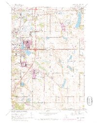
1967 Map of Lake Elmo
USGS Topo · Published 1973About this map
Northdale and the burgeoning suburbs east of St. Paul are captured here in a period of rapid mid-century expansion. The landscape transition from open farmland to residential clusters is evident in the development around Oakdale and Woodbury, where new schools like Royal Oak Sch and Woodbury Sch serve growing neighborhoods. Infrastructure of the era is prominently marked, including the Chicago and North Western rail line and a notable Correctional Institution near the Ramsey and Washington County boundary.
Find a feature on this map
67 named features on this map. Tap any name to fly to it.
Don’t see what you’re looking for? This feature index may not catch every label — zoom into the map to look around manually.
Map Details
Editions of this 1967 Lake Elmo Map
4 editions found
Other maps of this area

1896 · St. Paul
USGS Topo · 1:62,500

1902 · White Bear
USGS Topo · 1:62,500

1946 · Hudson
USGS Topo · 1:62,500

1948 · Stillwater
USGS Topo · 1:62,500

1949 · Hudson
USGS Topo · 1:62,500

1949 · Stillwater
USGS Topo · 1:62,500

1949 · Lake Elmo
USGS Topo · 1:24,000

1949 · Hudson
USGS Topo · 1:24,000

1950 · Lake Elmo
USGS Topo · 1:24,000

1950 · Hudson
USGS Topo · 1:24,000