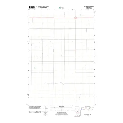
2011 Map of Lake Geneva
USGS Topo · Published 2011About this map
Burleigh County farm fields and small prairie wetlands characterize this landscape in the early twenty-first century. A primary east-west transport corridor bisects the northern section of the quadrangle, where the modern interstate runs parallel to Old Hwy 10. This layering of infrastructure reflects the evolution of transcontinental travel through the North Dakota plains, replacing the older highway route that once served as the region's main artery. The remainder of the terrain is defined by a rigid section-line road grid, including 444th St NE and 19th Ave SE, which organize the agricultural properties and provide access to the numerous small, unnamed sloughs and ponds scattered throughout the prairie. Local travel is facilitated by these gravel and dirt routes such as 431st St NE and 22nd Ave SE, which serve the rural farmsteads typical of this part of the state.
Find a feature on this map
19 named features on this map. Tap any name to fly to it.
Don’t see what you’re looking for? This feature index may not catch every label — zoom into the map to look around manually.
Map Details
Editions of this 2011 Lake Geneva Map
This is the sole edition of this map. No revisions or reprints were ever made.
Other maps of this area

1951 · Driscoll
USGS Topo · 1:62,500

1952 · Steele
USGS Topo · 1:24,000

1952 · Steele NW
USGS Topo · 1:24,000

1953 · Jamestown
USGS Topo · 1:250,000

1954 · Bismarck
USGS Topo · 1:250,000

1956 · Jamestown
USGS Topo · 1:250,000

1958 · Bismarck
USGS Topo · 1:250,000

1975 · Lake Geneva
USGS Topo · 1:24,000
1975 · Stony Slough
USGS Topo · 1:24,000
1975 · Clear Lake
USGS Topo · 1:24,000