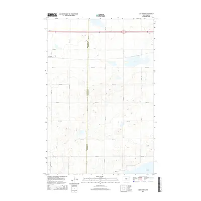
2014 Map of Lake Geneva
USGS Topo · Published 2014About this map
The boundary between Burleigh Co and Kidder Co bisects this prairie landscape, defined by its numerous wetlands and glacial depressions. At the heart of this North Dakota topography sits Lake Geneva, a significant water body in a region of undulating terrain. The map captures the organized grid of rural life, where long-standing section lines are traced by routes like Co Road 10 and 57th Ave Ne, providing access to the expansive agricultural tracts that define the area. To the south, the northern reaches of Long Lake begin to appear, signaling a shift toward the larger wetland complexes characteristic of this part of the state. The landscape is marked by a high density of small, unnamed potholes and seasonal basins, reflecting a classic Great Plains drainage pattern that has shaped local farming and land use for generations.
Find a feature on this map
29 named features on this map. Tap any name to fly to it.
Don’t see what you’re looking for? This feature index may not catch every label — zoom into the map to look around manually.
Map Details
Editions of this 2014 Lake Geneva Map
This is the sole edition of this map. No revisions or reprints were ever made.
Other maps of this area

1951 · Driscoll
USGS Topo · 1:62,500

1952 · Steele
USGS Topo · 1:24,000

1952 · Steele NW
USGS Topo · 1:24,000

1953 · Jamestown
USGS Topo · 1:250,000

1954 · Bismarck
USGS Topo · 1:250,000

1956 · Jamestown
USGS Topo · 1:250,000

1958 · Bismarck
USGS Topo · 1:250,000

1975 · Lake Geneva
USGS Topo · 1:24,000
1975 · Stony Slough
USGS Topo · 1:24,000
1975 · Clear Lake
USGS Topo · 1:24,000