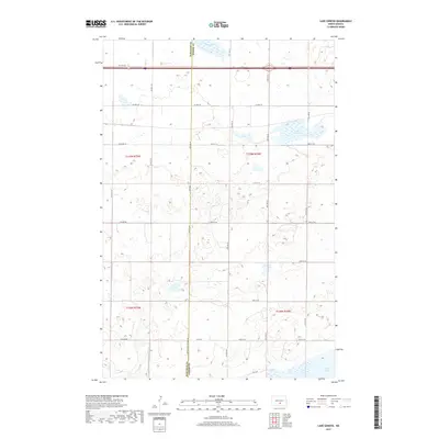
2017 Map of Lake Geneva
USGS Topo · Published 2017About this map
Lake Geneva and the surrounding prairie wetlands of the Missouri Plateau dominate this landscape along the border of Burleigh and Kidder counties. This 2017 survey details a sparsely populated agricultural region characterized by numerous small basins and larger water bodies like Stony Slough and the northern reaches of Long Lake. The geometric grid of the Public Land Survey System is clearly visible through the network of section line roads, including Co Hwy 10 and 57th Ave Ne, which facilitate travel between the remote farmsteads and fields of t139n r74w and t138n r74w. The map provides a precise view of the hydrology and topography of this portion of the North Dakota pothole region, where the elevation subtly shifts across the glacial till.
Find a feature on this map
29 named features on this map. Tap any name to fly to it.
Don’t see what you’re looking for? This feature index may not catch every label — zoom into the map to look around manually.
Map Details
Editions of this 2017 Lake Geneva Map
This is the sole edition of this map. No revisions or reprints were ever made.
Other maps of this area

1951 · Driscoll
USGS Topo · 1:62,500

1952 · Steele
USGS Topo · 1:24,000

1952 · Steele NW
USGS Topo · 1:24,000

1953 · Jamestown
USGS Topo · 1:250,000

1954 · Bismarck
USGS Topo · 1:250,000

1956 · Jamestown
USGS Topo · 1:250,000

1958 · Bismarck
USGS Topo · 1:250,000

1975 · Lake Geneva
USGS Topo · 1:24,000
1975 · Stony Slough
USGS Topo · 1:24,000
1975 · Clear Lake
USGS Topo · 1:24,000