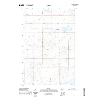
2020 Map of Lake Geneva
USGS Topo · Published 2020About this map
The boundary between Burleigh Co Kidder Co bisects a prairie landscape defined by significant water bodies and a grid of rural section roads. The northern reach of Long Lake dominates the southern edge of the survey, while Lake Geneva and Stony Slough serve as central landmarks within the rolling plains. This region is characterized by its agricultural organization, with townships such as t139n r75w and t138n r74w mapped out along a network of numbered arterial roads. Transportation across this portion of North Dakota relies on routes like Co Hwy 10 and 57th Ave Ne, which provide access to the intermittent wetlands and small lakes that dot the interior, illustrating the characteristic hydrology of the Missouri Plateau.
Find a feature on this map
21 named features on this map. Tap any name to fly to it.
Don’t see what you’re looking for? This feature index may not catch every label — zoom into the map to look around manually.
Map Details
Editions of this 2020 Lake Geneva Map
This is the sole edition of this map. No revisions or reprints were ever made.
Other maps of this area

1951 · Driscoll
USGS Topo · 1:62,500

1952 · Steele
USGS Topo · 1:24,000

1952 · Steele NW
USGS Topo · 1:24,000

1953 · Jamestown
USGS Topo · 1:250,000

1954 · Bismarck
USGS Topo · 1:250,000

1956 · Jamestown
USGS Topo · 1:250,000

1958 · Bismarck
USGS Topo · 1:250,000

1975 · Lake Geneva
USGS Topo · 1:24,000
1975 · Stony Slough
USGS Topo · 1:24,000
1975 · Clear Lake
USGS Topo · 1:24,000