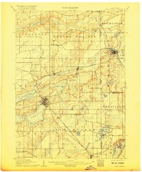
1906 Map of Lake Geneva
USGS Topo · Published 1917About this map
Lake Geneva serves as the central focal point of this Southern Wisconsin landscape, reflecting the region's transition into a prominent resort and agricultural hub in the early twentieth century. The map illustrates a well-developed grid of rail lines, including the Chicago and Northwestern Railroad and the Chicago Milwaukee and St Paul RR, which converge near key settlements like Genoa Junction and Lake Geneva. This dense transport network facilitated the movement of goods and visitors between the rural townships of Lyons and Bloomfield and the burgeoning city of Burlington along the Fox River. Local genealogists can trace the early footprints of small communities like Spring Prairie, North Bloomfield, and Zenda, while hydrologic features such as Lake Como and Powers Lake define the glacial topography that would eventually shape the area's recreational identity.
Find a feature on this map
46 named features on this map. Tap any name to fly to it.
Don’t see what you’re looking for? This feature index may not catch every label — zoom into the map to look around manually.
Map Details
Editions of this 1906 Lake Geneva Map
4 editions found

Other maps of this area

1891 · Muskego
USGS Topo · 1:62,500

1892 · Whitewater
USGS Topo · 1:62,500

1892 · Eagle
USGS Topo · 1:62,500

1893 · Delavan
USGS Topo · 1:62,500

1893 · Whitewater
USGS Topo · 1:62,500

1893 · Silver Lake
USGS Topo · 1:62,500

1893 · Geneva
USGS Topo · 1:62,500

1894 · Eagle
USGS Topo · 1:62,500

1897 · Eagle
USGS Topo · 1:62,500

1901 · Muskego
USGS Topo · 1:62,500