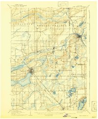
1906 Map of Lake Geneva
USGS Topo · Published 1941About this map
The glacial terrain of Walworth, Racine, and Kenosha counties is captured in high detail at the dawn of the twentieth century, defined by its complex network of lakes and drainage basins. Lake Geneva and Lake Como anchor the central-west region, while the Fox River snakes through Burlington, where the Wisconsin Central Railroad and the Chicago Milwaukee and St. Paul Railroad establish the area as a critical transportation hub. Smaller rural settlements like Spring Prairie, Slades Corners, and Vienna dot the surrounding agricultural townships.
Find a feature on this map
48 named features on this map. Tap any name to fly to it.
Don’t see what you’re looking for? This feature index may not catch every label — zoom into the map to look around manually.
Map Details
Editions of this 1906 Lake Geneva Map
4 editions found

Other maps of this area

1891 · Muskego
USGS Topo · 1:62,500

1892 · Whitewater
USGS Topo · 1:62,500

1892 · Eagle
USGS Topo · 1:62,500

1893 · Delavan
USGS Topo · 1:62,500

1893 · Whitewater
USGS Topo · 1:62,500

1893 · Silver Lake
USGS Topo · 1:62,500

1893 · Geneva
USGS Topo · 1:62,500

1894 · Eagle
USGS Topo · 1:62,500

1897 · Eagle
USGS Topo · 1:62,500

1901 · Muskego
USGS Topo · 1:62,500