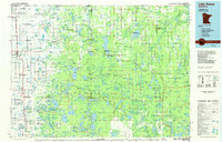
1985 Map of Lake Itasca
USGS Topo · Published 1985About this map
The White Earth Indian Reservation dominates this mid-1980s landscape, encompassing a vast network of glacial lakes and wetlands in northwestern Minnesota. The map documents the intricate conservation landscape of the era, where the Mississippi Headwaters State Forest and White Earth State Forest meet the protected boundaries of Itasca State Park. Significant local settlements like Mahnomen, White Earth, and Naytahwaush are shown alongside smaller outposts such as Elbow Lake Village and Bejou. The topography is marked by distinctive glacial features like Strawberry Mountain and Hogback Hill, while the Burlington Northern railroad corridor provides a clear industrial contrast to the surrounding Tamarac National Wildlife Refuge. This survey captures the transition between the agricultural plains and the dense forest and lake country of the Mississippi headwaters before modern development expanded.
Find a feature on this map
231 named features on this map. Tap any name to fly to it.
Don’t see what you’re looking for? This feature index may not catch every label — zoom into the map to look around manually.
Map Details
Editions of this 1985 Lake Itasca Map
2 editions found
Other maps of this area

1918 · Flom
USGS Topo · 1:62,500

1919 · Fosston
USGS Topo · 1:62,500

1919 · Solway
USGS Topo · 1:62,500

1919 · Valley
USGS Topo · 1:62,500

1920 · Buena Vista
USGS Topo · 1:62,500

1943 · Solway
USGS Topo · 1:62,500

1943 · Bagley
USGS Topo · 1:62,500

1952 · Grand Forks
USGS Topo · 1:250,000

1953 · Fargo
USGS Topo · 1:250,000

1953 · Brainerd
USGS Topo · 1:250,000