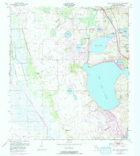
1953 Map of Lake June In Winter
USGS Topo · Published 1972About this map
Lake June in Winter dominates this Florida landscape, a massive water body surrounded by a network of smaller lakes and wetlands characteristic of the Highlands area. Surveyed in the early 1950s with photogrammetric revisions from 1972, the map shows a period of shifting land use, with a Golf Course and a Landing Strip appearing alongside traditional terrain features like Hog Island Hammock and Hen Scratch. The hydrology of the region is intricately detailed, from the flowing Josephine Creek and Fisheating Creek to clusters of smaller basins such as Persimmon Lake, Red Water Lake, and the trio of Center, Northwest, and Southeast Lake Nellie. The southern portion of the sheet shows the expanding City Boundary of Lake Placid, reflecting the mid-century growth of this citrus and retirement hub before more intensive modern development altered the shoreline further.
Find a feature on this map
24 named features on this map. Tap any name to fly to it.
Don’t see what you’re looking for? This feature index may not catch every label — zoom into the map to look around manually.
Map Details
Editions of this 1953 Lake June In Winter Map
3 editions found
Other maps of this area

1952 · Lake Placid
USGS Topo · 1:24,000

1952 · Lorida
USGS Topo · 1:24,000

1952 · Sebring
USGS Topo · 1:24,000

1953 · Lake June In Winter
USGS Topo · 1:24,000

1953 · Venus NW
USGS Topo · 1:24,000

1953 · Crewsville SE
USGS Topo · 1:24,000

1953 · Crewsville
USGS Topo · 1:24,000

1953 · Childs
USGS Topo · 1:24,000

1956 · Fort Pierce
USGS Topo · 1:250,000

1957 · Long Island Marsh NE
USGS Topo · 1:24,000