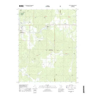
2017 Map of Lake Killarney
USGS Topo · Published 2017About this map
Saint Francois Mountains terrain defines this portion of the Missouri Ozarks, where the communities of Ironton and Arcadia sit at the edge of the Mark Twain National Forest. The landscape is a network of named peaks and hollows, including Crane Mtn, Tims Mtn, and the distinctive Wagon Wheel Gap. Water features like Stouts Creek and Lake Killarney provide the primary drainage for the area's many valleys. For those researching local family history, the map identifies numerous small burial sites such as Rebel Cem, Allgier Cem, and Blanton Cem tucked into the hills. The presence of the Pilot Knob National Wildlife Refuge in the northwest corner highlights the transition from the settled valley floors to the protected woodland ridges of Peck Mtn and Anderson Mtn.
Find a feature on this map
77 named features on this map. Tap any name to fly to it.
Don’t see what you’re looking for? This feature index may not catch every label — zoom into the map to look around manually.
Map Details
Editions of this 2017 Lake Killarney Map
This is the sole edition of this map. No revisions or reprints were ever made.
Other maps of this area

1926 · Des Arc
USGS Topo · 1:62,500

1929 · Des Arc
USGS Topo · 1:62,500

1930 · Coldwater
USGS Topo · 1:62,500

1937 · Ironton
USGS Topo · 1:48,000

1939 · Fredericktown
USGS Topo · 1:48,000

1945 · Ironton
USGS Topo · 1:62,500

1946 · Ironton
USGS Topo · 1:62,500

1947 · Fredericktown
USGS Topo · 1:62,500

1949 · Rolla
USGS Topo · 1:250,000

1949 · Coldwater
USGS Topo · 1:62,500