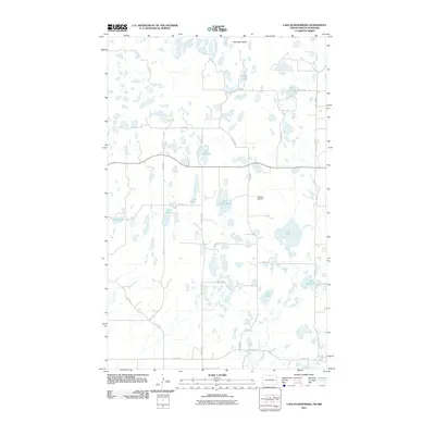
2011 Map of Lake Klingenberg
USGS Topo · Published 2011About this map
Lake Klingenberg and numerous prairie potholes define this landscape along the border of North Dakota and Manitoba in the early 21st century. The terrain is characterized by a dense network of small water bodies, including Long Lake, Lake Taylor, and Lake Southard, interspersed with a grid of rural roads like County Rd 49 and S Jule Rd. A prominent landmark, Boundary Butte, rises near the northern edge of the map, while the Manger Cemetery provides a localized point of genealogical interest. This drainage pattern, where smaller streams like Stone Creek and Oak Creek wind between the lakes, illustrates the unique hydrology of the northern plains. The road network, comprising numbered streets and avenues such as 108th St NE and 14th Ave NE, reflects the systematic land divisions used to manage this agricultural and marshy environment.
Find a feature on this map
32 named features on this map. Tap any name to fly to it.
Don’t see what you’re looking for? This feature index may not catch every label — zoom into the map to look around manually.
Map Details
Editions of this 2011 Lake Klingenberg Map
This is the sole edition of this map. No revisions or reprints were ever made.
Other maps of this area

1954 · Souris SE
USGS Topo · 1:24,000

1954 · Minot
USGS Topo · 1:250,000

1955 · Bottineau
USGS Topo · 1:24,000

1955 · Bottineau SE
USGS Topo · 1:24,000

1956 · Metigoshe Lake
USGS Topo · 1:24,000

1956 · Carbury
USGS Topo · 1:24,000

1956 · Lake McArthur
USGS Topo · 1:24,000

1958 · Minot
USGS Topo · 1:250,000

1980 · Bottineau
USGS Topo · 1:100,000
2011 · Carbury
USGS Topo · 1:24,000