
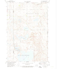
1972 Map of Lake Louise
USGS Topo · Published 1986About this map
Chase Lake National Wildlife Refuge and the National Waterfowl Production Area dominate this landscape on the border of Kidder and Stutsman counties. This 1970s environment is characterized by a dense network of prairie potholes and larger water bodies, including Chicago Lake, Fisher Lake, and the central Lake Louise. The area reflects a commitment to conservation and water management, with the State Wildlife Management Area protecting critical nesting grounds.
Find a feature on this map
14 named features on this map. Tap any name to fly to it.
Don’t see what you’re looking for? This feature index may not catch every label — zoom into the map to look around manually.
Map Details
Editions of this 1972 Lake Louise Map
2 editions found
Historical Maps of Stutsman County Through Time
227 maps found

1950 Carrington SW
Stutsman County, ND

1950 Fried
Stutsman County, ND

1950 Melville
Stutsman County, ND

1951 Arrowwood Lake
Stutsman County, ND

1951 Bordulac SW
Stutsman County, ND

1951 Eldridge NW
Stutsman County, ND

1951 Eldridge SE
Stutsman County, ND

1951 Fried
Stutsman County, ND

1951 Kensal SE
Stutsman County, ND

1952 Bloom
Stutsman County, ND

1952 Courtenay NW
Stutsman County, ND

1952 Eldridge
Stutsman County, ND

1952 Eldridge SW
Stutsman County, ND

1952 Homer
Stutsman County, ND

1952 Jim Lake
Stutsman County, ND

1952 Jud NW
Stutsman County, ND

1952 Pingree SW
Stutsman County, ND

1953 Cleveland SE
Stutsman County, ND

1953 Cleveland SW
Stutsman County, ND

1953 Millarton
Stutsman County, ND

1953 Montpelier NW
Stutsman County, ND

1954 Cleveland NW
Stutsman County, ND

1955 Crystal Springs
Stutsman County, ND

1955 Medina SE
Stutsman County, ND

1955 Medina SW
Stutsman County, ND

1958 Goldwin SE
Stutsman County, ND

1958 Goldwin
Stutsman County, ND

1958 Goldwin SW
Stutsman County, ND

1958 Vashti
Stutsman County, ND
1972 Lake Louise
Stutsman County, ND

1972 Pearl Lake
Stutsman County, ND

1972 Woodworth NW
Stutsman County, ND

1975 Medina SW
Stutsman County, ND

1978 Hawks Nest
Stutsman County, ND

1978 Sykeston SW
Stutsman County, ND

1983 Gackle NE
Stutsman County, ND

1983 Gackle North
Stutsman County, ND

1983 Streeter NW
Stutsman County, ND

1990 Courtenay NW
Stutsman County, ND

1990 Eldridge NW
Stutsman County, ND

1990 Eldridge SE
Stutsman County, ND

1990 Eldridge
Stutsman County, ND

1990 Fried
Stutsman County, ND

1990 Homer
Stutsman County, ND

1990 Jim Lake
Stutsman County, ND

1990 Pingree SW
Stutsman County, ND

1991 Eldridge SW
Stutsman County, ND

2011 Arrowwood Lake
Stutsman County, ND

2011 Bloom
Stutsman County, ND

2011 Bordulac SW
Stutsman County, ND

2011 Carrington SW
Stutsman County, ND

2011 Cleveland NW
Stutsman County, ND

2011 Cleveland SE
Stutsman County, ND

2011 Cleveland SW
Stutsman County, ND

2011 Courtenay NW
Stutsman County, ND

2011 Crystal Springs
Stutsman County, ND

2011 Eldridge NW
Stutsman County, ND

2011 Eldridge SE
Stutsman County, ND

2011 Eldridge
Stutsman County, ND

2011 Eldridge SW
Stutsman County, ND

2011 Fried
Stutsman County, ND

2011 Gackle NE
Stutsman County, ND

2011 Gackle North
Stutsman County, ND

2011 Goldwin SE
Stutsman County, ND

2011 Goldwin
Stutsman County, ND

2011 Goldwin SW
Stutsman County, ND

2011 Hawks Nest
Stutsman County, ND

2011 Homer
Stutsman County, ND

2011 Jim Lake
Stutsman County, ND

2011 Jud NW
Stutsman County, ND

2011 Kensal SE
Stutsman County, ND

2011 Lake Louise
Stutsman County, ND

2011 Medina SE
Stutsman County, ND

2011 Medina SW
Stutsman County, ND

2011 Melville
Stutsman County, ND

2011 Millarton
Stutsman County, ND

2011 Montpelier NW
Stutsman County, ND

2011 Pearl Lake
Stutsman County, ND

2011 Pingree SW
Stutsman County, ND

2011 Streeter NW
Stutsman County, ND

2011 Sykeston SW
Stutsman County, ND

2011 Vashti
Stutsman County, ND

2011 Woodworth NW
Stutsman County, ND

2014 Arrowwood Lake
Stutsman County, ND

2014 Bloom
Stutsman County, ND

2014 Bordulac SW
Stutsman County, ND

2014 Carrington SW
Stutsman County, ND

2014 Cleveland NW
Stutsman County, ND

2014 Cleveland SE
Stutsman County, ND

2014 Cleveland SW
Stutsman County, ND

2014 Courtenay NW
Stutsman County, ND

2014 Crystal Springs
Stutsman County, ND

2014 Eldridge NW
Stutsman County, ND

2014 Eldridge SE
Stutsman County, ND

2014 Eldridge
Stutsman County, ND

2014 Eldridge SW
Stutsman County, ND

2014 Fried
Stutsman County, ND

2014 Gackle NE
Stutsman County, ND

2014 Gackle North
Stutsman County, ND

2014 Goldwin SE
Stutsman County, ND

2014 Goldwin
Stutsman County, ND

2014 Goldwin SW
Stutsman County, ND

2014 Hawks Nest
Stutsman County, ND

2014 Homer
Stutsman County, ND

2014 Jim Lake
Stutsman County, ND

2014 Jud NW
Stutsman County, ND

2014 Kensal SE
Stutsman County, ND

2014 Lake Louise
Stutsman County, ND

2014 Medina SE
Stutsman County, ND

2014 Medina SW
Stutsman County, ND

2014 Melville
Stutsman County, ND

2014 Millarton
Stutsman County, ND

2014 Montpelier NW
Stutsman County, ND

2014 Pearl Lake
Stutsman County, ND

2014 Pingree SW
Stutsman County, ND

2014 Streeter NW
Stutsman County, ND

2014 Sykeston SW
Stutsman County, ND

2014 Vashti
Stutsman County, ND

2014 Woodworth NW
Stutsman County, ND

2017 Arrowwood Lake
Stutsman County, ND

2017 Bordulac SW
Stutsman County, ND

2017 Cleveland NW
Stutsman County, ND

2017 Cleveland SE
Stutsman County, ND

2017 Cleveland SW
Stutsman County, ND

2017 Eldridge NW
Stutsman County, ND

2017 Jim Lake
Stutsman County, ND

2017 Jud NW
Stutsman County, ND

2017 Millarton
Stutsman County, ND

2017 Montpelier NW
Stutsman County, ND

2017 Streeter NW
Stutsman County, ND

2018 Bloom
Stutsman County, ND

2018 Carrington SW
Stutsman County, ND

2018 Courtenay NW
Stutsman County, ND

2018 Crystal Springs
Stutsman County, ND

2018 Eldridge SE
Stutsman County, ND

2018 Eldridge
Stutsman County, ND

2018 Eldridge SW
Stutsman County, ND

2018 Fried
Stutsman County, ND

2018 Gackle NE
Stutsman County, ND

2018 Gackle North
Stutsman County, ND

2018 Goldwin SE
Stutsman County, ND

2018 Goldwin
Stutsman County, ND

2018 Goldwin SW
Stutsman County, ND

2018 Hawks Nest
Stutsman County, ND

2018 Homer
Stutsman County, ND

2018 Kensal SE
Stutsman County, ND

2018 Lake Louise
Stutsman County, ND

2018 Medina SE
Stutsman County, ND

2018 Medina SW
Stutsman County, ND

2018 Melville
Stutsman County, ND

2018 Pearl Lake
Stutsman County, ND

2018 Pingree SW
Stutsman County, ND

2018 Sykeston SW
Stutsman County, ND

2018 Vashti
Stutsman County, ND

2018 Woodworth NW
Stutsman County, ND

2020 Arrowwood Lake
Stutsman County, ND

2020 Bloom
Stutsman County, ND

2020 Bordulac SW
Stutsman County, ND

2020 Carrington SW
Stutsman County, ND

2020 Cleveland NW
Stutsman County, ND

2020 Cleveland SE
Stutsman County, ND

2020 Cleveland SW
Stutsman County, ND

2020 Courtenay NW
Stutsman County, ND

2020 Crystal Springs
Stutsman County, ND

2020 Eldridge NW
Stutsman County, ND

2020 Eldridge SE
Stutsman County, ND

2020 Eldridge
Stutsman County, ND

2020 Eldridge SW
Stutsman County, ND

2020 Fried
Stutsman County, ND

2020 Gackle NE
Stutsman County, ND

2020 Gackle North
Stutsman County, ND

2020 Goldwin SE
Stutsman County, ND

2020 Goldwin
Stutsman County, ND

2020 Goldwin SW
Stutsman County, ND

2020 Hawks Nest
Stutsman County, ND

2020 Homer
Stutsman County, ND

2020 Jim Lake
Stutsman County, ND

2020 Jud NW
Stutsman County, ND

2020 Kensal SE
Stutsman County, ND

2020 Lake Louise
Stutsman County, ND

2020 Medina SE
Stutsman County, ND

2020 Medina SW
Stutsman County, ND

2020 Melville
Stutsman County, ND

2020 Millarton
Stutsman County, ND

2020 Montpelier NW
Stutsman County, ND

2020 Pearl Lake
Stutsman County, ND

2020 Pingree SW
Stutsman County, ND

2020 Streeter NW
Stutsman County, ND

2020 Sykeston SW
Stutsman County, ND

2020 Vashti
Stutsman County, ND

2020 Woodworth NW
Stutsman County, ND

2024 Arrowwood Lake
Stutsman County, ND

2024 Bloom
Stutsman County, ND

2024 Bordulac SW
Stutsman County, ND

2024 Carrington SW
Stutsman County, ND

2024 Cleveland NW
Stutsman County, ND

2024 Cleveland SE
Stutsman County, ND

2024 Cleveland SW
Stutsman County, ND

2024 Courtenay NW
Stutsman County, ND

2024 Crystal Springs
Stutsman County, ND

2024 Eldridge NW
Stutsman County, ND

2024 Eldridge SE
Stutsman County, ND

2024 Eldridge
Stutsman County, ND

2024 Eldridge SW
Stutsman County, ND

2024 Fried
Stutsman County, ND

2024 Gackle NE
Stutsman County, ND

2024 Gackle North
Stutsman County, ND

2024 Goldwin SE
Stutsman County, ND

2024 Goldwin
Stutsman County, ND

2024 Goldwin SW
Stutsman County, ND

2024 Hawks Nest
Stutsman County, ND

2024 Homer
Stutsman County, ND

2024 Jim Lake
Stutsman County, ND

2024 Jud NW
Stutsman County, ND

2024 Kensal SE
Stutsman County, ND

2024 Lake Louise
Stutsman County, ND

2024 Medina SE
Stutsman County, ND

2024 Medina SW
Stutsman County, ND

2024 Melville
Stutsman County, ND

2024 Millarton
Stutsman County, ND

2024 Montpelier NW
Stutsman County, ND

2024 Pearl Lake
Stutsman County, ND

2024 Pingree SW
Stutsman County, ND

2024 Streeter NW
Stutsman County, ND

2024 Sykeston SW
Stutsman County, ND

2024 Vashti
Stutsman County, ND

2024 Woodworth NW
Stutsman County, ND