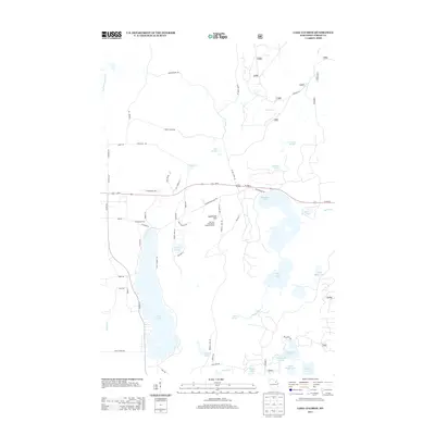
2013 Map of Lake Lucerne
USGS Topo · Published 2013About this map
Lake Lucerne and its surrounding glacial terrain define this portion of the Wisconsin Northwoods, where water and forest dominate the landscape. In the early 21st century, the area remains a dense network of lakes and springs, including Wabikon Lake, Devils Lake, and Bug Lake. A significant point of interest is Sugarbush Hill, which serves as the location for the Rat Lake Permanent Lookout Station, a remnant of the region's fire monitoring infrastructure. The road network reflects both modern transit and historical access, with Us-8 bisecting the quadrangle while smaller routes like the Potawatomi Mile Trl and Keith Siding Rd hint at the area's timber and rail history. Numerous water sources such as the S Br Peshtigo River, Indian River, and Rat River drain through the marshes and highlands, sustaining the secluded character of Forest County.
Find a feature on this map
74 named features on this map. Tap any name to fly to it.
Don’t see what you’re looking for? This feature index may not catch every label — zoom into the map to look around manually.
Map Details
Editions of this 2013 Lake Lucerne Map
This is the sole edition of this map. No revisions or reprints were ever made.
Other maps of this area

1939 · Crandon
USGS Topo · 1:48,000

1939 · Laona
USGS Topo · 1:48,000

1941 · Crandon
USGS Topo · 1:48,000

1942 · Wabeno
USGS Topo · 1:48,000

1942 · Pearson
USGS Topo · 1:48,000

1946 · Laona
USGS Topo · 1:48,000

1947 · Crandon
USGS Topo · 1:48,000

1950 · Wabeno
USGS Topo · 1:48,000

1950 · Lily
USGS Topo · 1:48,000

1951 · Wabeno
USGS Topo · 1:48,000