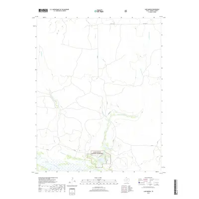
2019 Map of Lake Marvin
USGS Topo · Published 2019About this map
Black Kettle National Grassland preserves a significant portion of this Texas Panhandle landscape, where the flat upland plains are dissected by a complex network of ephemeral watercourses. The drainage system is dominated by Persimmon Cr and the winding Boggy Cr, both of which feed toward the wide, braided corridor of the Canadian River visible along the southern boundary. This area represents a critical intersection of conservation land and ranching heritage, with local infrastructure like Iv Ranch Rd and various county roads providing access to the interior. Recreation and water management are centralized at Lake Marvin and the nearby Lake Kiowa, where the E Shore Trail follows the water's edge. The presence of Dry Fork Boggy Cr further illustrates the seasonal hydrology that defines life in Hemphill County.
Find a feature on this map
18 named features on this map. Tap any name to fly to it.
Don’t see what you’re looking for? This feature index may not catch every label — zoom into the map to look around manually.
Map Details
Editions of this 2019 Lake Marvin Map
This is the sole edition of this map. No revisions or reprints were ever made.
Other maps of this area

1954 · Perryton
USGS Topo · 1:250,000

1954 · Amarillo
USGS Topo · 1:250,000

1958 · Perryton
USGS Topo · 1:250,000

1958 · Amarillo
USGS Topo · 1:250,000

1967 · Gem
USGS Topo · 1:24,000

1967 · Blue Ridge School
USGS Topo · 1:24,000

1967 · Canadian SE
USGS Topo · 1:24,000

1972 · Canadian East
USGS Topo · 1:24,000

1972 · Glazier
USGS Topo · 1:24,000
1972 · Lake Marvin
USGS Topo · 1:24,000