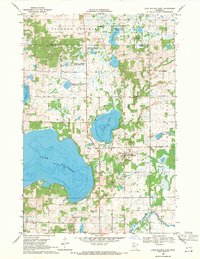
1969 Map of Lake Miltona East
USGS Topo · Published 1971About this map
The glacial landscape of central Minnesota is defined by the massive expanse of Lake Miltona, which dominates the western half of this 1969 survey. To its east, Lake Irene and smaller water bodies like Rainy Lake are interspersed with numerous Gravel Pits, indicating the importance of local material extraction for the region's development. The settlement of Miltona serves as the local hub, while the southern margin reaches the northern edge of Lake Carlos State Park, complete with its Campground.
Find a feature on this map
24 named features on this map. Tap any name to fly to it.
Don’t see what you’re looking for? This feature index may not catch every label — zoom into the map to look around manually.
Map Details
Editions of this 1969 Lake Miltona East Map
This is the sole edition of this map. No revisions or reprints were ever made.
Other maps of this area

1953 · Brainerd
USGS Topo · 1:250,000

1953 · Saint Cloud
USGS Topo · 1:250,000

1957 · Brainerd
USGS Topo · 1:250,000

1957 · Saint Cloud
USGS Topo · 1:250,000

1958 · Saint Cloud
USGS Topo · 1:250,000

1958 · Brainerd
USGS Topo · 1:250,000

1965 · Brainerd
USGS Topo · 1:250,000

1966 · Alexandria West
USGS Topo · 1:24,000

1966 · Lake Osakis West
USGS Topo · 1:24,000

1966 · Alexandria East
USGS Topo · 1:24,000