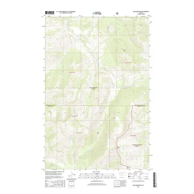
2017 Map of Lake Mountain
USGS Topo · Published 2017About this map
The North Fork Blackfoot River carves through this high-altitude landscape where the Lolo National Forest meets the Helena National Forest. Centered on the prominence of Lake Mountain, the terrain is defined by steep elevation changes and significant landmarks such as Big Slide and Mineral Hill. The drainage network is complex, featuring the Dry Fork North Fork Blackfoot River and numerous tributaries like Madison Cr and Jakey Cr. This area, situated along the border of Lewis and Clark and Powell counties, remains a primitive wilderness environment. Notable natural features include the North Fork Falls and the relatively level Sourdough Flats, providing a stark contrast to the surrounding peaks. The map serves as a detailed record of this protected backcountry before modern shifts in forest management, documenting the primitive access points at Windy Pass and the remote reaches of Falls Point.
Find a feature on this map
25 named features on this map. Tap any name to fly to it.
Don’t see what you’re looking for? This feature index may not catch every label — zoom into the map to look around manually.
Map Details
Editions of this 2017 Lake Mountain Map
This is the sole edition of this map. No revisions or reprints were ever made.
Other maps of this area

1902 · Ovando
USGS Topo · 1:125,000

1903 · Coopers Lake
USGS Topo · 1:125,000

1905 · Ovando
USGS Topo · 1:125,000

1955 · Choteau
USGS Topo · 1:250,000

1957 · Choteau
USGS Topo · 1:250,000

1958 · Choteau
USGS Topo · 1:250,000

1962 · Choteau
USGS Topo · 1:250,000

1968 · Spread Mountain
USGS Topo · 1:24,000

1968 · Olson Peak
USGS Topo · 1:24,000
1968 · Coopers Lake
USGS Topo · 1:24,000