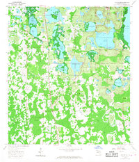
1959 Map of Lake Nellie
USGS Topo · Published 1968About this map
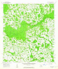
The expansive wetlands of the Green Swamp dominate this central Florida landscape, revealing a complex network of hydrologic features as they appeared in the late 1950s. The map captures a transition between the elevated lake region to the north and the dense, low-lying swamp to the south. Significant water bodies such as Lake Nellie, Lake Glona, and Pine Island Lake are centered among groves and ridges, while the southern half of the sheet dissolves into the Alligator Lake Swamp and Bay Swamp. Evidence of early resource management and local infrastructure is visible through the presence of a Lookout Tower and a Gaging Sta along the water's edge. This topographic record preserves the original names of numerous small islands and ponds, like Black Jack Island and Leggy Pond, many of which sit in areas that remain critical for Florida's groundwater recharge.
Find a feature on this map
33 named features on this map. Tap any name to fly to it.
Don’t see what you’re looking for? This feature index may not catch every label — zoom into the map to look around manually.
Map Details
Editions of this 1959 Lake Nellie Map
4 editions found
Other maps of this area

1955 · Orlando
USGS Topo · 1:250,000

1957 · Orlando
USGS Topo · 1:250,000

1958 · Orlando
USGS Topo · 1:250,000

1959 · Lake Nellie
USGS Topo · 1:24,000

1959 · Lake Louisa
USGS Topo · 1:24,000

1959 · Lake Louisa SW
USGS Topo · 1:24,000

1959 · Poyner
USGS Topo · 1:24,000
1960 · Bay Lake
USGS Topo · 1:24,000
1960 · Rock Ridge
USGS Topo · 1:24,000

1962 · Orlando
USGS Topo · 1:250,000