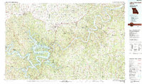
1983 Map of Lake Of The Ozarks
USGS Topo · Published 1984About this map
Lake of the Ozarks dominates this central Missouri landscape, its complex shoreline defined by the Gravois Arm, Niangua Arm, and Grand Glaize Arm. The map reveals a region where water and rail networks converge, particularly around the St Louis Southwestern railroad line. Settlement patterns follow the winding course of the Osage River, with the historic seat at Tuscumbia and smaller communities like Bagnell and Eldon serving as local hubs.
Find a feature on this map
129 named features on this map. Tap any name to fly to it.
Don’t see what you’re looking for? This feature index may not catch every label — zoom into the map to look around manually.
Map Details
Editions of this 1983 Lake Of The Ozarks Map
This is the sole edition of this map. No revisions or reprints were ever made.
Other maps of this area

1884 · Bolivar
USGS Topo · 1:125,000

1886 · Jefferson City
USGS Topo · 1:125,000

1887 · Sedalia
USGS Topo · 1:125,000

1887 · Warsaw
USGS Topo · 1:125,000

1888 · Versailles
USGS Topo · 1:125,000

1888 · Tuscumbia
USGS Topo · 1:125,000

1888 · Boonville
USGS Topo · 1:125,000

1890 · Fulton
USGS Topo · 1:125,000

1892 · Bolivar
USGS Topo · 1:125,000

1893 · Versailles
USGS Topo · 1:125,000