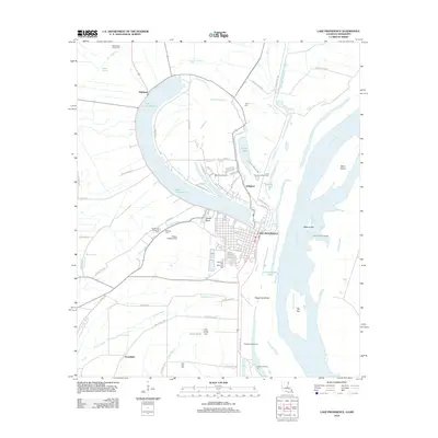
2012 Map of Lake Providence
USGS Topo · Published 2012About this map
The oxbow of Lake Providence dominates this Mississippi River landscape, reflecting the ancient shifts of the river channel before modern engineering stabilized its course. The seat of East Carroll Parish, Lake Providence, sits on the southern bend of its namesake lake, where the street grid transitions from the commercial center to residential neighborhoods like Arlington and Highland. This survey captures the complex drainage and water management systems required in the delta, including the Tensas Basin, Cottonwood Chute, and various revetments along the riverbanks. To the west, the landscape is defined by agricultural lands and bayous, including Tensas Bayou and Winters Bayou. Genealogists and local historians will find several rural burial grounds preserved in the record, such as Tyrone Cem, Way Way Cem, and the Old Sweet Canaan Cem. Aviation history is also represented through the presence of both Byerley Airport and Wilson Landing Field.
Find a feature on this map
73 named features on this map. Tap any name to fly to it.
Don’t see what you’re looking for? This feature index may not catch every label — zoom into the map to look around manually.
Map Details
Editions of this 2012 Lake Providence Map
This is the sole edition of this map. No revisions or reprints were ever made.
Other maps of this area

1909 · Baxter Bayou
USGS Topo · 1:24,000

1909 · Lake Providence
USGS Topo · 1:24,000

1909 · Wilsons Point
USGS Topo · 1:24,000

1909 · Millikin
USGS Topo · 1:24,000

1909 · Ashton Bridge
USGS Topo · 1:24,000

1911 · Lake Providence
USGS Topo · 1:31,680

1911 · Baxter Bayou
USGS Topo · 1:24,000

1912 · Ashton Bridge
USGS Topo · 1:31,680

1913 · Wilson Point
USGS Topo · 1:31,680

1914 · Baxter Bayou
USGS Topo · 1:31,680