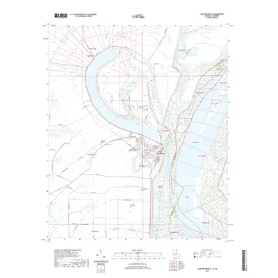
2020 Map of Lake Providence
USGS Topo · Published 2020About this map
The oxbow of Lake Providence dominates this landscape, reflecting an older path of the Mississippi River that now flows to the east. Along the lake’s inner curve, the town of Lake Providence serves as the hub of East Carroll Parish, anchored by the East Carroll Parish Courthouse and the Louisiana Technical College Margaret Surles Branch. The surrounding alluvial plain of the Tensas Basin is defined by a dense network of bayous and drainage features, including Baxter Bayou, Tensas Bayou, and Winters Bayou. In the southern reaches, the settlement of Greenfield sits near the banks of Boggy Bayou, while the northern area is marked by the community of Highland. This map captures the complex relationship between the fertile river bottomlands and the modern infrastructure required to manage it, from the Byerley Airport to the various parish roads that lace through the historic land grants and townships.
Find a feature on this map
103 named features on this map. Tap any name to fly to it.
Don’t see what you’re looking for? This feature index may not catch every label — zoom into the map to look around manually.
Map Details
Editions of this 2020 Lake Providence Map
This is the sole edition of this map. No revisions or reprints were ever made.
Other maps of this area

1909 · Baxter Bayou
USGS Topo · 1:24,000

1909 · Lake Providence
USGS Topo · 1:24,000

1909 · Wilsons Point
USGS Topo · 1:24,000

1909 · Millikin
USGS Topo · 1:24,000

1909 · Ashton Bridge
USGS Topo · 1:24,000

1911 · Lake Providence
USGS Topo · 1:31,680

1911 · Baxter Bayou
USGS Topo · 1:24,000

1912 · Ashton Bridge
USGS Topo · 1:31,680

1913 · Wilson Point
USGS Topo · 1:31,680

1914 · Baxter Bayou
USGS Topo · 1:31,680