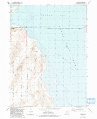
1991 Map of Lake Side
USGS Topo · Published 1991About this map
Lakeside serves as a critical rail and communications node along the southern edge of Gunnison Bay, positioned where the historic Lucin Cutoff strikes across the waters of the Great Salt Lake. This 1991 revision illustrates the complex relationship between industrial infrastructure and the unforgiving desert terrain of the Lakeside Mountains. The map details the operations of the Utah Test and Training Range, which occupies the desolate Sedal Valley and North Valley to the south. Notable geological and navigational landmarks such as Lakeside Butte and the curiously named Aardvark Arch provide orientation in a landscape defined by sharp ridges like Death Ridge and the cluster of peaks known as The Gillespies. Small-scale extraction is evident through scattered quarry and prospect labels near the shoreline.
Find a feature on this map
30 named features on this map. Tap any name to fly to it.
Don’t see what you’re looking for? This feature index may not catch every label — zoom into the map to look around manually.
Map Details
Editions of this 1991 Lake Side Map
This is the sole edition of this map. No revisions or reprints were ever made.
Other maps of this area

1954 · Brigham City
USGS Topo · 1:250,000

1958 · Brigham City
USGS Topo · 1:250,000

1962 · Brigham City
USGS Topo · 1:250,000

1968 · Carrington Island SW
USGS Topo · 1:24,000

1968 · Deardens Knoll
USGS Topo · 1:24,000

1969 · Rozel Point SW
USGS Topo · 1:24,000

1969 · Gunnison Island SW
USGS Topo · 1:24,000

1969 · Carrington Island NW
USGS Topo · 1:24,000

1969 · Strongs Knob
USGS Topo · 1:24,000

1969 · Gunnison Island
USGS Topo · 1:24,000