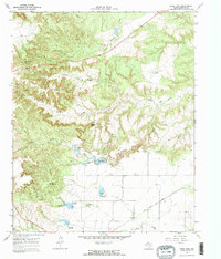
1967 Map of Lake Theo
USGS Topo · Published 1970About this map
John Haynes Ridge dominates the northern landscape of this Briscoe County territory, where the Caprock Escarpment meets the rolling plains. The 1960s terrain is defined by a network of deep-cut drainage prongs and creeks, including Mexican Creek and the Little Red River, which carve through the breaks. Water management is central to the area's development, evidenced by the recently established Lake Theo, Hawkins Lake, and Dry Creek Lake.
Find a feature on this map
22 named features on this map. Tap any name to fly to it.
Don’t see what you’re looking for? This feature index may not catch every label — zoom into the map to look around manually.
Map Details
Editions of this 1967 Lake Theo Map
3 editions found
Other maps of this area

1954 · Plainview
USGS Topo · 1:250,000

1958 · Plainview
USGS Topo · 1:250,000

1960 · Indian Peak
USGS Topo · 1:62,500

1960 · Brice
USGS Topo · 1:62,500

1967 · Quitaque
USGS Topo · 1:24,000

1967 · Edgemon Lake
USGS Topo · 1:24,000

1967 · Hay Lake
USGS Topo · 1:24,000

1967 · Turkey
USGS Topo · 1:24,000

1967 · Lake Theo
USGS Topo · 1:24,000
1967 · Folley
USGS Topo · 1:24,000