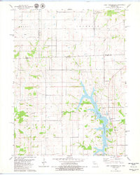
1979 Map of Lake Thunderhead
USGS Topo · Published 1980About this map
Lake Thunderhead dominates the southern landscape of this Missouri and Iowa borderland, its dendritic fingers reaching into the surrounding townships of Sherman and Franklin. This late-1970s survey captures the region as the reservoir altered the local drainage of North Blackbird Creek, creating a new recreational focal point complete with a Campground and Roadside Park. The map preserves the older rural fabric of the border counties, showing the small settlement of Genoa and scattered spiritual centers like Mt Zion Ch and Wesley Chapel. Transportation and infrastructure are represented by the Unionville Airport and a prominent Water Tank near the lake's eastern shore, while the upland areas remain defined by traditional agricultural section lines and small family burial grounds including Livingston Cem and Union Cem.
Find a feature on this map
23 named features on this map. Tap any name to fly to it.
Don’t see what you’re looking for? This feature index may not catch every label — zoom into the map to look around manually.
Map Details
Editions of this 1979 Lake Thunderhead Map
This is the sole edition of this map. No revisions or reprints were ever made.
Other maps of this area

1912 · Green City
USGS Topo · 1:62,500

1914 · Green City
USGS Topo · 1:62,500

1939 · Centerville
USGS Topo · 1:62,500

1941 · Centerville
USGS Topo · 1:62,500

1942 · Seymour
USGS Topo · 1:62,500

1944 · Seymour
USGS Topo · 1:62,500

1954 · Centerville
USGS Topo · 1:250,000

1957 · Centerville
USGS Topo · 1:250,000

1958 · Centerville
USGS Topo · 1:250,000

1964 · Pollock NW
USGS Topo · 1:24,000