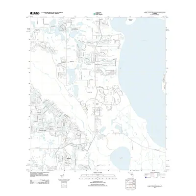
2012 Map of Lake Tohopekaliga
USGS Topo · Published 2012About this map
Lake Tohopekaliga dominates the eastern horizon of this 2012 survey, its expansive shoreline defining the residential growth patterns of Osceola County. The suburban landscape of Poinciana Place and Johnson shows a complex network of winding drives and cul-de-sacs, such as Octavia Blvd and S Poinciana Blvd, which weave around the numerous small lakes and wetlands characteristic of the Florida interior. A central corridor is formed by Pleasant Hill Rd, which passes the Pleasant Hill Cem as it moves south toward Lake Russell. This period of development is marked by the close proximity of nature preserves and water bodies like Brown Lake and the meandering Reedy Cr, illustrating the 21st-century balance between rapid residential expansion and the preservation of the region's aquatic ecosystems and islands, including Makinson Island.
Find a feature on this map
157 named features on this map. Tap any name to fly to it.
Don’t see what you’re looking for? This feature index may not catch every label — zoom into the map to look around manually.
Map Details
Editions of this 2012 Lake Tohopekaliga Map
This is the sole edition of this map. No revisions or reprints were ever made.
Other maps of this area

1953 · Cypress Lake
USGS Topo · 1:24,000

1953 · Dundee
USGS Topo · 1:24,000

1953 · Lake Hatchineha
USGS Topo · 1:24,000

1953 · St Cloud North
USGS Topo · 1:24,000

1953 · St Cloud South
USGS Topo · 1:24,000

1953 · Lake Tohopekaliga
USGS Topo · 1:24,000

1953 · Kissimmee
USGS Topo · 1:24,000

1953 · Intercession City
USGS Topo · 1:24,000

1953 · Davenport
USGS Topo · 1:24,000

1955 · Orlando
USGS Topo · 1:250,000