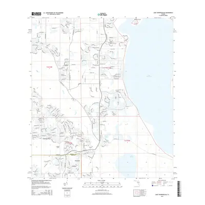
2015 Map of Lake Tohopekaliga
USGS Topo · Published 2015About this map
Poinciana and the surrounding marshlands of Osceola and Polk Counties are documented here in detail, showcasing the extensive residential development of the early 21st century. The landscape is defined by its complex hydrology, with the western shore of Lake Tohopekaliga and the waters of Lake Russell framing the community. The map reveals a transition from traditional land markers like the Pleasant Hill Cem to modern neighborhood layouts such as Poinciana Place and Johnson. The intricate network of drainage and waterways is evident along Reedy Cr, illustrating how the suburban footprint has been integrated into the Central Florida wetlands. Significant local landmarks include Makinson Island in the north and the cluster of settlements at Johnson Island, providing a clear record of the area's growth patterns and its relationship with the prominent regional lake system.
Find a feature on this map
251 named features on this map. Tap any name to fly to it.
Don’t see what you’re looking for? This feature index may not catch every label — zoom into the map to look around manually.
Map Details
Editions of this 2015 Lake Tohopekaliga Map
This is the sole edition of this map. No revisions or reprints were ever made.
Other maps of this area

1953 · Cypress Lake
USGS Topo · 1:24,000

1953 · Dundee
USGS Topo · 1:24,000

1953 · Lake Hatchineha
USGS Topo · 1:24,000

1953 · St Cloud North
USGS Topo · 1:24,000

1953 · St Cloud South
USGS Topo · 1:24,000

1953 · Lake Tohopekaliga
USGS Topo · 1:24,000

1953 · Kissimmee
USGS Topo · 1:24,000

1953 · Intercession City
USGS Topo · 1:24,000

1953 · Davenport
USGS Topo · 1:24,000

1955 · Orlando
USGS Topo · 1:250,000