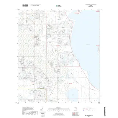
2018 Map of Lake Tohopekaliga
USGS Topo · Published 2018About this map
Lake Tohopekaliga dominates the eastern horizon of this 2018 survey, its expansive waters met by a complex network of residential development and preserved wetlands. The rapid growth of Poinciana and Poinciana Place is evident in the dense grid of modern streets such as Octavia Blvd and S Poinciana Blvd, which contrast sharply with the wilder reaches of the Reedy Creek Swamp. This transition between human settlement and the Florida landscape is most visible near Pleasant Hill Cem, where neighborhood expansion pushes right to the edge of the wetlands. To the south, Lake Russell and Brown Lake remain surrounded by marshy terrain, while Makinson Island and Johnson Island provide topographical variety within the waterways. The map also records the jurisdictional boundary where Osceola Co and Polk Co meet amidst this expanding suburban corridor.
Find a feature on this map
170 named features on this map. Tap any name to fly to it.
Don’t see what you’re looking for? This feature index may not catch every label — zoom into the map to look around manually.
Map Details
Editions of this 2018 Lake Tohopekaliga Map
This is the sole edition of this map. No revisions or reprints were ever made.
Other maps of this area

1953 · Cypress Lake
USGS Topo · 1:24,000

1953 · Dundee
USGS Topo · 1:24,000

1953 · Lake Hatchineha
USGS Topo · 1:24,000

1953 · St Cloud North
USGS Topo · 1:24,000

1953 · St Cloud South
USGS Topo · 1:24,000

1953 · Lake Tohopekaliga
USGS Topo · 1:24,000

1953 · Kissimmee
USGS Topo · 1:24,000

1953 · Intercession City
USGS Topo · 1:24,000

1953 · Davenport
USGS Topo · 1:24,000

1955 · Orlando
USGS Topo · 1:250,000