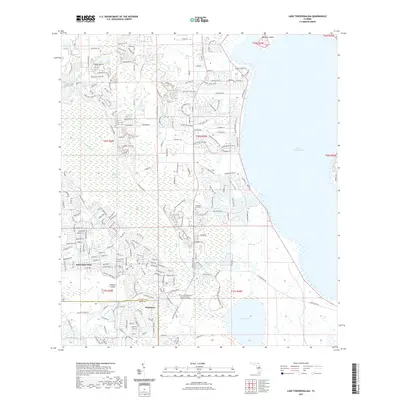
2021 Map of Lake Tohopekaliga
USGS Topo · Published 2021About this map
The master-planned community of Poinciana spans the boundary of the Osceola and Polk County line in this modern topographical study. The landscape is defined by the massive expanse of Lake Tohopekaliga to the east and the ecologically diverse Reedy Creek Swamp to the west. Residential growth is evident in the dense street networks of Poinciana Place and around Johnson Island, while the Technical Education Center Osceola serves as a local hub for education. Cultural and physical history is anchored by the Pleasant Hill Cemetery, situated near the headwaters of Reedy Creek. Further south, the undeveloped basin of Lake Russell and the wetlands of Brown Lake provide a sharp contrast to the suburban expansion to the north, illustrating the delicate balance between Central Florida development and its native hydrology.
Find a feature on this map
208 named features on this map. Tap any name to fly to it.
Don’t see what you’re looking for? This feature index may not catch every label — zoom into the map to look around manually.
Map Details
Editions of this 2021 Lake Tohopekaliga Map
This is the sole edition of this map. No revisions or reprints were ever made.
Other maps of this area

1953 · Cypress Lake
USGS Topo · 1:24,000

1953 · Dundee
USGS Topo · 1:24,000

1953 · Lake Hatchineha
USGS Topo · 1:24,000

1953 · St Cloud North
USGS Topo · 1:24,000

1953 · St Cloud South
USGS Topo · 1:24,000

1953 · Lake Tohopekaliga
USGS Topo · 1:24,000

1953 · Kissimmee
USGS Topo · 1:24,000

1953 · Intercession City
USGS Topo · 1:24,000

1953 · Davenport
USGS Topo · 1:24,000

1955 · Orlando
USGS Topo · 1:250,000