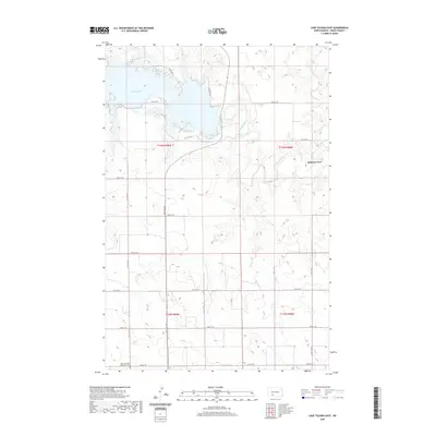
2020 Map of Lake Tschida East
USGS Topo · Published 2020About this map
The waters of Lake Tschida dominate the northern landscape of this Grant County region, where the Heart River valley meets the high plains of North Dakota. In the southwest corner, the Hope Lutheran (Old Stone) Cem serves as a significant genealogical marker for the early families who settled these sections. The map reveals the intricate network of section-line roads, such as 68th Ave SW and 60th St SW, which define the agricultural grid of the Heart River basin. Further east, the river winds toward the natural crossing at Johnson Ford, illustrating the historical movement across this riparian corridor. The proximity of Cabin Area 1 near the lake's edge highlights the contemporary transition toward recreational land use along the shoreline of Heart Butte Creek.
Find a feature on this map
25 named features on this map. Tap any name to fly to it.
Don’t see what you’re looking for? This feature index may not catch every label — zoom into the map to look around manually.
Map Details
Editions of this 2020 Lake Tschida East Map
This is the sole edition of this map. No revisions or reprints were ever made.
Other maps of this area

1938 · Heart Butte
USGS Topo · 1:48,000

1944 · Heart Butte
USGS Topo · 1:62,500

1954 · Bismarck
USGS Topo · 1:250,000

1958 · Bismarck
USGS Topo · 1:250,000

1960 · Heart Butte NW
USGS Topo · 1:24,000

1960 · Heart Butte
USGS Topo · 1:24,000

1980 · Crown Butte Creek NW
USGS Topo · 1:24,000
1980 · Lake Tschida East
USGS Topo · 1:24,000

1980 · Heil
USGS Topo · 1:24,000

1980 · Crown Butte Creek SW
USGS Topo · 1:24,000