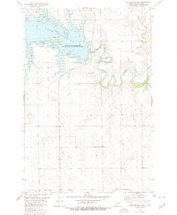
1980 Map of Lake Tschida East
USGS Topo · Published 1980About this map
Lake Tschida dominates this Grant County landscape, formed by the impoundment of the Heart River behind the Heart Butte Dam. This 1980 survey illustrates the developed recreation and conservation infrastructure surrounding the reservoir, including several Campgrounds, a Picnic Area, and the sprawling Heart Butte Reservoir State Game Management Area. The map reveals the intricate drainage system of the Missouri Plateau, where Boy Scout Creek, Schatz Creek, and Heart Butte Creek feed into the central valley.
Find a feature on this map
16 named features on this map. Tap any name to fly to it.
Don’t see what you’re looking for? This feature index may not catch every label — zoom into the map to look around manually.
Map Details
Editions of this 1980 Lake Tschida East Map
This is the sole edition of this map. No revisions or reprints were ever made.
Other maps of this area

1938 · Heart Butte
USGS Topo · 1:48,000

1944 · Heart Butte
USGS Topo · 1:62,500

1954 · Bismarck
USGS Topo · 1:250,000

1958 · Bismarck
USGS Topo · 1:250,000

1960 · Heart Butte NW
USGS Topo · 1:24,000

1960 · Heart Butte
USGS Topo · 1:24,000

1980 · Crown Butte Creek NW
USGS Topo · 1:24,000

1980 · Heil
USGS Topo · 1:24,000

1980 · Crown Butte Creek SW
USGS Topo · 1:24,000
1980 · Elgin
USGS Topo · 1:24,000