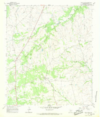
1967 Map of Lake Victor
USGS Topo · Published 1969About this map
Lake Victor sits at the heart of this landscape, serving as a hub for the surrounding ranching and extraction lands in Burnet County. The presence of an Old Railroad Grade running through the settlement indicates the shifting transportation priorities of the late 1960s, as former rail corridors gave way to local road networks. The terrain is deeply etched by a complex drainage system, including the North Fork San Gabriel River and numerous branches like Allen Branch and South Rocky Creek. This survey is particularly valuable for genealogical research, documenting family-linked landmarks such as Tomlinson Cem, Dobyville Cem, and Double Cem. Numerous Gravel Pit sites scattered across the topography reflect the local importance of aggregate mining in the area's mid-century economy.
Find a feature on this map
20 named features on this map. Tap any name to fly to it.
Don’t see what you’re looking for? This feature index may not catch every label — zoom into the map to look around manually.
Map Details
Editions of this 1967 Lake Victor Map
This is the sole edition of this map. No revisions or reprints were ever made.
Other maps of this area

1887 · Lampasas
USGS Topo · 1:125,000

1887 · Burnet
USGS Topo · 1:125,000

1893 · Burnet
USGS Topo · 1:125,000

1894 · Lampasas
USGS Topo · 1:125,000

1903 · Burnet
USGS Topo · 1:125,000

1909 · Burnet
USGS Topo · 1:125,000

1932 · Tow
USGS Topo · 1:62,500

1954 · Brownwood
USGS Topo · 1:250,000

1954 · Lampasas
USGS Topo · 1:62,500

1954 · Lampasas
USGS Topo · 1:24,000