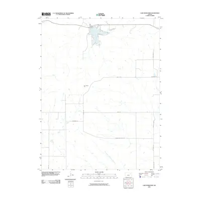
2009 Map of Lake Wabaunsee
USGS Topo · Published 2009About this map
Lake Wabaunsee serves as the focal point of this northern Kansas landscape, formed by the Eskridge City Dam at the head of a winding drainage system. The terrain is defined by a dense network of waterways, including Rock Creek, Locust Creek, and the uniquely named One Hundred and Forty-two Mile Creek. This 2009 survey reflects a rural environment where land use is etched into the road names, with routes like Wildau Ranch Ln and Wheat Ranch Rd hinting at the agricultural legacy of the region. Local landmarks such as Gun Barrel Hill rise above the creeks, while a grid of county roads provides access to the scattered homesteads and ranches. The map documents the area's transition toward residential lakeside living along W Flint Hills Dr and Lakeshore Dr, contrasting with the more isolated reaches of Hungry Hollow Rd to the east.
Find a feature on this map
23 named features on this map. Tap any name to fly to it.
Don’t see what you’re looking for? This feature index may not catch every label — zoom into the map to look around manually.
Map Details
Editions of this 2009 Lake Wabaunsee Map
This is the sole edition of this map. No revisions or reprints were ever made.
Other maps of this area

1885 · Eskridge
USGS Topo · 1:125,000

1889 · Eskridge
USGS Topo · 1:125,000

1894 · Eskridge
USGS Topo · 1:125,000

1955 · Hutchinson
USGS Topo · 1:250,000

1959 · Hutchinson
USGS Topo · 1:250,000
1971 · Admire
USGS Topo · 1:24,000
1971 · Allendorph
USGS Topo · 1:24,000

1971 · Alta Vista SE
USGS Topo · 1:24,000

1971 · Allen
USGS Topo · 1:24,000

1971 · Bushong
USGS Topo · 1:24,000